What you need
- The three values for your location: azimuth, elevation and skew
- A compass or smartphone — and the magnetic azimuth, not the true one
- Spanners for the mast, elevation and LNB bolts
- A receiver with a signal display, or a meter, for fine-tuning
1What the three numbers mean
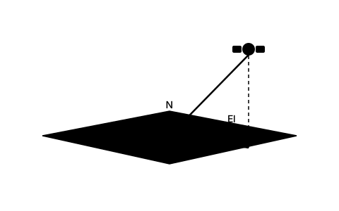
Azimuth is the compass direction the dish points in, measured from north through east. In the British Isles it comes out around 140 to 146 degrees for Astra 28.2 — well round to the south-east, not due south as many expect.
Elevation is the angle above the horizon. For Astra 28.2 it runs between about 21 degrees in Scotland and Ireland and 25 degrees in the south of England. That is flat — flatter than most people expect — and it is exactly why a single tree can block reception.
Skew is the rotation of the LNB in its holder. It makes the two receiving probes inside the LNB match the horizontally and vertically polarised waves from the satellite. Without it the installation still works in fair weather — and drops one plane at the first rain.
2The values for your city
The table shows azimuth, elevation and LNB skew for several cities. All values are computed with the same formulas the SatFinder App uses and refer to the city centre.
The azimuth here is a true value. If you are working with a compass you have to apply the magnetic declination to it — currently close to zero across the British Isles, from about one degree east in London to one or two degrees west in Ireland, which is small but not nothing. On an 80 cm dish with roughly two degrees of beamwidth, every degree counts.
| Location | Azimuth | Elevation | Skew |
|---|---|---|---|
| London | 145.4° | 25.4° | 13.2° |
| Birmingham | 143.8° | 23.8° | 13.6° |
| Manchester | 143.8° | 22.9° | 13.1° |
| Dublin | 139.5° | 21.4° | 15.3° |
3Astra 19.2° East outside Germany, Austria and Switzerland
Astra 19.2° East is not only aimed at the German-speaking countries. Its footprint covers most of western and central Europe, and in the Netherlands, Belgium, Luxembourg, France, Denmark, Poland, the Czech Republic or on the Spanish coast many households point a dish at it for German-language channels or their own country's satellite packages. The table below gives the values for the larger cities in that area.
The skew column already includes Astra's 7.5-degree pre-rotation, just like the British table above. East of a line through the middle of Germany the value is negative (Warsaw, Budapest), west of it positive (Amsterdam, Paris, Madrid) — and it grows the further you move away from that line.
The further you are from the centre of the footprint, the weaker the signal. In the Benelux countries, Denmark, Poland and the Czech Republic a standard 60 to 80 cm dish is usually enough; on the Spanish Mediterranean coast and the Balearics installers typically fit 80 cm to well over 1 m, more the further south-west you go. For your exact address, choose Astra 19.2° East in the SatFinder App or use the calculator link at the end of this guide.
| Location | Azimuth | Elevation | Skew |
|---|---|---|---|
| Amsterdam (NL) | 162.2° | 28.6° | 3.3° |
| Rotterdam (NL) | 161.5° | 29.0° | 3.8° |
| Brussels (BE) | 161.1° | 30.1° | 4.3° |
| Antwerp (BE) | 161.3° | 29.7° | 4.1° |
| Luxembourg (LU) | 163.0° | 31.7° | 3.4° |
| Paris (FR) | 158.1° | 31.6° | 6.7° |
| Strasbourg (FR) | 164.9° | 33.2° | 2.4° |
| Copenhagen (DK) | 172.0° | 26.3° | −3.0° |
| Aarhus (DK) | 169.2° | 25.5° | −1.5° |
| Warsaw (PL) | 182.3° | 30.2° | −8.9° |
| Kraków (PL) | 181.0° | 32.6° | −8.1° |
| Wrocław (PL) | 177.2° | 31.4° | −5.8° |
| Gdańsk (PL) | 179.3° | 28.0° | −7.1° |
| Prague (CZ) | 173.8° | 32.4° | −3.5° |
| Brno (CZ) | 176.6° | 33.5° | −5.3° |
| Bratislava (SK) | 177.2° | 34.7° | −5.6° |
| Budapest (HU) | 179.8° | 35.4° | −7.4° |
| Milan (IT) | 166.1° | 36.7° | 2.2° |
| Barcelona (ES) | 155.1° | 39.1° | 10.9° |
| Madrid (ES) | 146.9° | 37.7° | 17.1° |
| Alicante (ES) | 150.0° | 41.1° | 15.6° |
| Palma (ES) | 155.0° | 41.1° | 11.5° |
| Málaga (ES) | 143.8° | 40.7° | 20.7° |
4How the values spread across the country
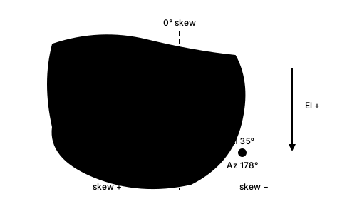
The numbers move in two directions, and both follow a simple rule. The further south you live, the higher the satellite sits: Manchester needs about 23 degrees of elevation, London around 25. Across the country the spread is only a few degrees.
Azimuth follows the east-west axis. The further west you stand, the further round from south the satellite lies — Dublin points at 139.5 degrees, London at 145.4. And the skew is large everywhere here, between 13 and 15 degrees in the table cities, because the whole of these islands lies far west of 28.2° East.
Those figures already include Astra's pre-rotation: SES transmits from 28.2° East (and from 19.2° and 23.5° East) with the polarisation plane turned by 7.5°, so that Germany needs almost no skew. Purely geometric calculators therefore show about 7.5 degrees more for the same city. Satellites without an offset, such as Hotbird 13° East, change sign exactly at their own meridian.
In practice: between two neighbouring towns little changes, between Dublin and London a fair amount. Take the value for a city 300 kilometres away and you are already outside the usable window.
5From the table value to a mounted dish
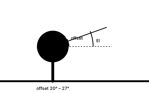
Set elevation first, because it is the only one of the three you can set exactly without a signal. Use the degree scale on the mount, not the back of the reflector.
This is where most self-installations come unstuck: on an offset dish the reflector stands considerably steeper than the elevation suggests, because the offset angle of the reflector is subtracted from the elevation — 20 to 27 degrees depending on the model. At 25 degrees of elevation and 24 degrees of offset the reflector leans back only about 1 degree from the vertical: it stands practically upright. The scale on the mount, by contrast, already refers to elevation and simply reads 25.
Then azimuth: loosen the mast clamp only enough that the dish turns with effort, and sweep slowly — about one degree every two seconds. Finally the skew at the LNB. Tighten everything hand-tight, check the values again, then tighten properly.
6If your town is not in the table
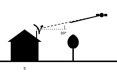
The values change continuously with coordinates, so there are no jumps. Between two cities you can interpolate linearly: if your place lies halfway, take the mean. That works very well for elevation, usably for azimuth, and for skew too.
An example: Leeds lies roughly between Manchester and Newcastle. Elevation therefore around 22 to 23 degrees, azimuth around 144. That puts you safely inside the catch range, and fine-tuning does the rest.
What you should not do: take a value from a city in another country, or use a table for a different satellite. Both put you out by orders of magnitude, not by fractions of a degree.
7Why a calculated value beats any table
A table refers to the city centre. But large cities are twenty kilometres across, and the edge already differs noticeably from the middle. On top of that, values from different sources are computed for slightly different satellite positions — Astra does not sit at exactly 28.20 degrees but drifts within its station-keeping box.
The SatFinder App computes azimuth, elevation and skew for your actual coordinates, gives the azimuth in magnetic form as well and takes the declination from the World Magnetic Model. That removes the conversion step at which most mistakes happen up at the mast.
And wherever your values come from: the last tenths of a degree always come from signal quality, never from the number. The table gets you into the catch range — tuning in is still your job.
Frequently asked questions
How do I align my dish to Astra 28.2° East?
You need three values for your location: azimuth, elevation and LNB skew. Across the British Isles the azimuth runs about 139 to 146 degrees, elevation between 21 and 25 degrees, skew around 13 to 15 degrees (Astra's 7.5-degree polarisation offset included). Set elevation on the degree scale first, then azimuth, finally skew — and fine-tune on signal quality at the end.
What azimuth is Astra 28.2 in my city?
The table in step 2 gives the values: London 145.4°, Birmingham 143.8°, Manchester 143.8°, Dublin 139.5°. All figures are true azimuths; on a compass you must apply the magnetic declination, currently within about two degrees of zero.
What are the values for Astra 19.2° East in the Netherlands, Poland or Spain?
Step 3 has a table for the larger cities outside Germany, Austria and Switzerland: Amsterdam 162.2° azimuth, 28.6° elevation, 3.3° skew; Warsaw 182.3°, 30.2° and −8.9°; Madrid 146.9°, 37.7° and 17.1°. The skew includes Astra's 7.5-degree pre-rotation, the azimuths are true values — on a compass, apply the local magnetic declination. In Spain the signal is weaker than in central Europe, so plan on a larger dish.
How high above the horizon does Astra 28.2 sit?
Between about 21 degrees in Scotland and Ireland and 25 degrees in southern England. As a rule of thumb elevation rises by about one degree per hundred kilometres you move south. That is flat enough for a single tree forty metres away to block reception.
My town is not in the table — what now?
Interpolate between two cities your place lies between: the values change continuously, without jumps. That lands you safely in the catch range. It gets more accurate if you have the values computed for your actual coordinates — a table always refers to the city centre.
Why does my dish stand far steeper than the elevation figure?
Because on offset dishes the offset angle of the reflector is subtracted from the elevation, 20 to 27 degrees depending on the model. At 25 degrees of elevation and 24 degrees of offset the reflector therefore leans back only about 1 degree from the vertical — it stands practically upright. The degree scale on the mount already refers to elevation and shows the right value.
Do I really need the skew?
Yes, even though the installation runs without it at first. A wrong skew does not lower signal strength but quality — and then the channels on one polarisation plane drop out first in rain. Across the British Isles the value for Astra 28.2 is around 13 to 15 degrees, including the 7.5 degrees by which Astra pre-rotates its polarisation.