What you need
- Spanners or a ratchet in 10, 13 and 17 mm (depending on the mount)
- Spirit level — a short torpedo level is easiest on a mast
- Compass, or a phone with a compass app
- Satellite meter or a receiver with a signal display at the dish
- Coaxial cable (75 Ω, double screened) and F connectors matching the cable diameter
- Cable stripper or knife, side cutters
- Self-amalgamating tape for the outdoor connection
- A second person to read the meter while you turn the dish
1Pick a spot with a clear line of sight
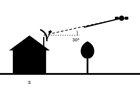
From the UK and Ireland the satellite sits to the south and fairly low — typically between 20° and 26° elevation. Anything in that direction that rises above the sight line blocks reception: trees, neighbouring buildings, roof overhangs, chimneys.
Stand where you intend to mount the dish and look south. Estimate the angle: 25° elevation is roughly a quarter of the way from the horizon to straight overhead. If something is in the way, no larger dish and no better LNB will fix it — the location is unsuitable.
Trees are the classic mistake. Everything works in winter with the branches bare, then the signal disappears in May. Judge the tree in leaf, and add a few years of growth for young ones.
2Mount the mast — and get it truly plumb
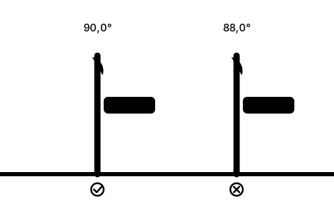
This step is the most underestimated and the most punishing. The azimuth scale on the dish mount assumes the dish rotates around a vertical axis. If the mast leans, every turn also changes the elevation — you end up chasing two angles at once and find the satellite only by luck.
Put the spirit level against the mast in two directions 90° apart and adjust until the bubble is centred in both. Only then tighten the wall bracket fully, and check again afterwards — fixings settle as they are torqued.
The mast also has to be stiff. A pole that moves a degree in the wind will reliably cost you dropouts in winter.
3Work out azimuth, elevation and skew for your location
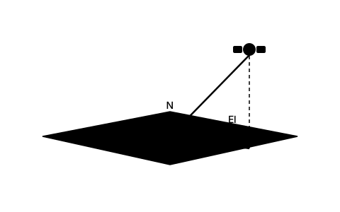
Three angles fully describe the alignment. Azimuth is the compass direction in degrees, measured from north (0°) through east (90°) and south (180°). Elevation is the angle above the horizon. Skew is how far the LNB has to be rotated in its holder so the polarisation planes line up.
All three depend on your location and the satellite's orbital position. For Astra 28.2°E — the satellite used by Sky and Freesat — the values across the UK and Ireland are in this range:
| Location | Azimuth | Elevation | Skew |
|---|---|---|---|
| London | 145.4° | 25.4° | 13.2° |
| Birmingham | 143.8° | 23.8° | 13.6° |
| Manchester | 143.8° | 22.9° | 13.1° |
| Dublin | 139.5° | 21.4° | 15.3° |
4Account for magnetic declination
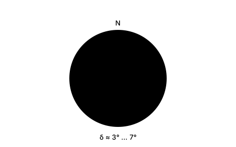
This is where installations quietly go wrong. Calculated azimuth values are true bearings — they refer to the geographic north pole. A compass points at the magnetic north pole, which moves. The difference is called magnetic declination, or variation.
Across the UK it is currently around 0° to 2° west, in central Europe roughly 3° to 6° east. So a compass reads several degrees off — on an 80 cm dish that is already half the usable window.
Either convert the true azimuth to a magnetic one (magnetic azimuth = true azimuth − easterly declination), or use a tool that gives you both. The SatFinder App shows true and magnetic azimuth separately and derives the declination for your coordinates from the World Magnetic Model.
5Set the elevation — watch out on offset dishes
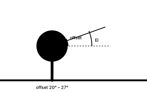
Almost every domestic dish is an offset antenna: the LNB does not sit centrally in front of the reflector but on an arm below it. That makes the reflector stand noticeably steeper than the reception angle would suggest.
And that is the trap. On most models the degree scale on the mount is already calibrated for the offset angle. You set the calculated elevation value there — not the physical tilt you would measure with a spirit level against the rim. At 25° elevation the reflector looks far steeper, often nearly vertical. That is correct.
If your dish's own instructions explicitly say the offset angle (typically 20° to 27°) must be subtracted, follow that instead. When in doubt: set the scale to the calculated elevation, nip the bolts up finger tight, and verify with the meter.
Set the elevation before the azimuth and lock it. Searching two axes at once takes many times longer.
6Set the azimuth: sweep slowly, don't hunt
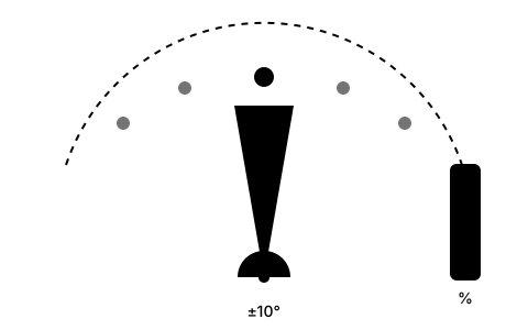
Loosen the mast clamp bolts just enough that the dish turns with some resistance — it should stay where you let go. Turn it roughly to the calculated (magnetic) azimuth.
Then sweep in very small steps: one to two degrees, then wait three to five seconds. Receivers and meters need that time to lock onto the signal. Sweeping briskly takes you straight past the satellite without the meter ever reacting — the single most common reason for hours of fruitless searching.
Cover about ±10° around the calculated value. If there is nothing there, something fundamental is wrong: elevation mixed up, declination ignored, or the cable is not feeding voltage to the LNB.
7Set the LNB skew
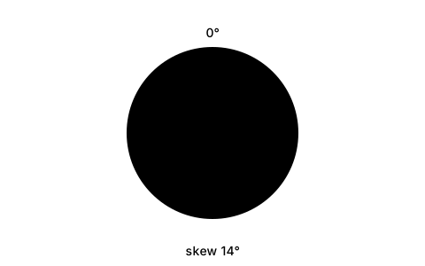
The LNB separates horizontally and vertically polarised signals. Because your location sits to one side of the satellite's longitude, the polarisation plane appears rotated from where you stand — and the LNB has to be turned in its holder by exactly that angle. On Astra there is a second part: the satellite transmits its polarisation plane pre-rotated by 7.5°.
Most LNB holders have a small degree scale for this. Loosen the clamp, turn the LNB to the calculated skew value and retighten. Positive values normally mean clockwise as seen from behind the LNB; when in doubt, trust the scale on your holder.
For Astra 28.2°E from the UK the values are substantial — typically 11° to 17°, with Astra's 7.5° pre-rotation already included. Getting them wrong lets the opposite polarisation bleed through and is the difference between 70 % and 90 % signal quality.
8Fine-tuning: optimise for quality, not strength
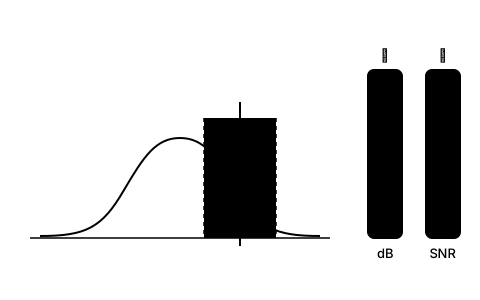
Meters and receivers show two numbers, and they mean different things. Signal strength is essentially the level arriving at the input — it rises even if you are receiving noise. Signal quality (often shown as SNR or MER) describes how cleanly the signal can be decoded. Only that number matters.
Work one axis at a time: sweep the azimuth in millimetre steps until quality peaks, then lock it. Do the same for elevation, then the skew. Afterwards recheck azimuth and elevation — tightening almost always pulls the setting slightly.
Aim for the plateau, not the peak. Find the two points where quality starts to fall off on either side and set the dish halfway between them. That gives you the maximum margin for rain, snow and wind movement — exactly the margin that decides whether you get dropouts in autumn.
Finally tighten everything down with a sensible amount of force and read the quality once more.
9Cable, F connectors and weatherproofing
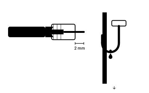
A perfectly aligned dish is worthless if the cable lets water in. Use double-screened 75 Ω coaxial cable and F connectors that match the diameter — an oversized connector never seals.
Making off the cable: strip the outer jacket, fold the braid cleanly back, remove the foil, trim the dielectric. The centre conductor should protrude about 2 mm from the connector. Not one strand of the braid may touch the centre conductor — that is the most common cause of "it worked yesterday".
Form a drip loop: run the cable in a downward curve below the connection before it goes to the wall entry. Rainwater then runs off at the lowest point instead of into the connector.
Wrap the finished outdoor joint in self-amalgamating tape, overlapping from the bottom upwards so the layers shed running water. PVC insulating tape is not suitable; it lets go after the first summer.
10Troubleshooting when there is no signal
Nothing at all: first check the LNB is getting power. The receiver feeds 13/18 V up the coax — a short in the connector or a broken centre conductor looks exactly like a misaligned dish on the meter. Then re-check the elevation, then the declination.
Signal present but some channels missing: this almost always points at the skew or at marginal alignment. Typically a whole polarisation plane or the upper frequency band drops out.
Picture breaks up in rain: the alignment is on target but has no margin. Re-trim to the middle of the plateau; if that is not enough, the dish is too small for your location or the reflector is distorted.
It used to work and now it doesn't: check in this order — water in the connector, trees that have grown, a dish moved by a storm, a failing LNB. LNBs often do not die outright, they just lose one band.
Frequently asked questions
How accurately does a satellite dish need to be aligned?
An 80 cm dish has a half-power beamwidth of about 2°. In practice you start losing measurable signal quality from around 0.5° off, and from about 1° it becomes marginal in bad weather. Smaller dishes are easier to point but leave less margin in rain.
Can I align a dish without a meter?
Yes — with a receiver and a TV at the dish, or an app that shows the receiver's signal level. It takes longer because the display reacts more slowly. Without any signal feedback a usable alignment is not possible: the calculated angles get you to the right region, but only measurement finds the last tenths of a degree.
Why can't I find the satellite even though the angles are right?
The three most common causes are: magnetic declination was ignored (the compass reads several degrees off), the mast is not plumb, or the sweep was too fast for the receiver to ever lock on. Also check the LNB is actually receiving voltage.
Do I really need to set the LNB skew?
Yes. For Astra 28.2°E from the UK the skew is typically 11° to 17° — far too large to ignore, even after the 7.5° by which Astra pre-rotates its polarisation. A wrong skew lets the opposite polarisation bleed in and costs signal quality. The further your location sits east or west of the satellite's longitude, the larger and more important the angle becomes.
What dish size do I need?
In the UK and Ireland a 60 to 80 cm dish gives stable reception from Astra 28.2°E, with 80 cm offering noticeably more margin in heavy rain. Towards the edge of a satellite's footprint, or for weaker satellites, larger diameters become necessary.
How long does aligning a dish take?
With the angles prepared, a plumb mast and a meter, one to two hours is realistic — most of it mounting and cabling. The fine-tuning itself rarely takes more than 15 minutes if the preparation was done properly.